top5に行ってみよう!! 新潟編
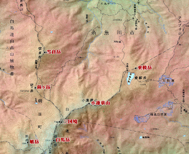
1.小蓮華山 (大日岳) ( コレンゲサン (ダイニチダケ) 2766 m) 新潟県糸魚川市、長野県北安曇郡小谷村
<36.462537 137.463415>
[googlemap lat=”36.77378311647054″ lng=”137.7758288383484″ align=”undefined” width=”300px” height=”150px” zoom=”11″ type=”G_NORMAL_MAP”]36.773783,137.775829[/googlemap]
★
2.三国境 ( ミクニザカイ 2751 m) 新潟県糸魚川市・富山県下新川郡朝日町・長野県北安曇郡小谷村
<36.455818 137.454479>
[googlemap lat=”36.766323287045765″ lng=”137.76248216629028″ align=”undefined” width=”300px” height=”150px” zoom=”11″ type=”G_NORMAL_MAP”]36.773783,137.775829[/googlemap]
★
3.雪倉岳 ( ユキクラダケ 2610.9 m) 新潟県糸魚川市・富山県下新川郡朝日町
<36.474072 137.451451>
[googlemap lat=”36.79464615762389″ lng=”137.75395274162292″ align=”undefined” width=”300px” height=”150px” zoom=”10″ type=”G_NORMAL_MAP”]36.773783,137.775829[/googlemap]
★
4. 鉢ヶ岳 ( ハチガタケ 2563 m) 新潟県糸魚川市・富山県下新川郡朝日町
<36.464874 137.445832>
[googlemap lat=”36.78036572709454″ lng=”137.7494466304779″ align=”undefined” width=”300px” height=”150px” zoom=”12″ type=”G_NORMAL_MAP”]36.773783,137.775829[/googlemap]
★
5.乗鞍岳 (白馬乗鞍岳) ( ノリクラダケ 2469 m) 新潟県糸魚川市・長野県北安曇郡小谷村
<36.471779 137.475713>
[googlemap lat=”36.788124919354686″ lng=”137.79856860637665″ align=”undefined” width=”300px” height=”150px” zoom=”10″ type=”G_NORMAL_MAP”]36.773783,137.775829[/googlemap]
★
1.城崎山 ( キザキヤマ 16.7 m) 新潟県上越市柿崎区
<37.161724 138.231286>
[googlemap lat=”37.2714861959214″ lng=”138.387481123209″ align=”undefined” width=”300px” height=”150px” zoom=”12″ type=”G_NORMAL_MAP”]36.773783,137.775829[/googlemap]

★
2.船岡山 ( フナオカヤマ 28 m) 新潟県新発田市横岡
<38.000630 139.223430>
[googlemap lat=”38.00189486472802″ lng=”139.3762707710266″ align=”undefined” width=”300px” height=”150px” zoom=”12″ type=”G_NORMAL_MAP”]36.773783,137.775829[/googlemap]

★
3.城山 ( シロヤマ 37.8 m) 新潟県佐渡市小木町
<37.484919 138.164281>
[googlemap lat=”37.81336299262781″ lng=”138.2783916592598″ align=”undefined” width=”300px” height=”150px” zoom=”12″ type=”G_NORMAL_MAP”]36.773783,137.775829[/googlemap]

★
4.鳥越山 ( トリゴエヤマ 40 m) 新潟県村上市浜新保
<38.213929 139.270394>
[googlemap lat=”38.360789148715426″ lng=”139.4510132074356″ align=”undefined” width=”300px” height=”150px” zoom=”12″ type=”G_NORMAL_MAP”]36.773783,137.775829[/googlemap]

★
5.茶臼山 ( チャウスヤマ 43 m) 新潟県上越市頸城区
<37.113849 138.223730>
[googlemap lat=”37.19407639294991″ lng=”138.37692260742188″ align=”undefined” width=”300px” height=”150px” zoom=”12″ type=”G_NORMAL_MAP”]36.773783,137.775829[/googlemap]

★
2011 年 3 月 4 日